Geospatial intelligence · Post-fire risk

The fire passes.
Water flows on.

Connect burned areas to what could affect water abstraction. Wildfires, rainfall and river networks in one view.

From landscape to evidence. From evidence to decisions.

Post-fire priorities
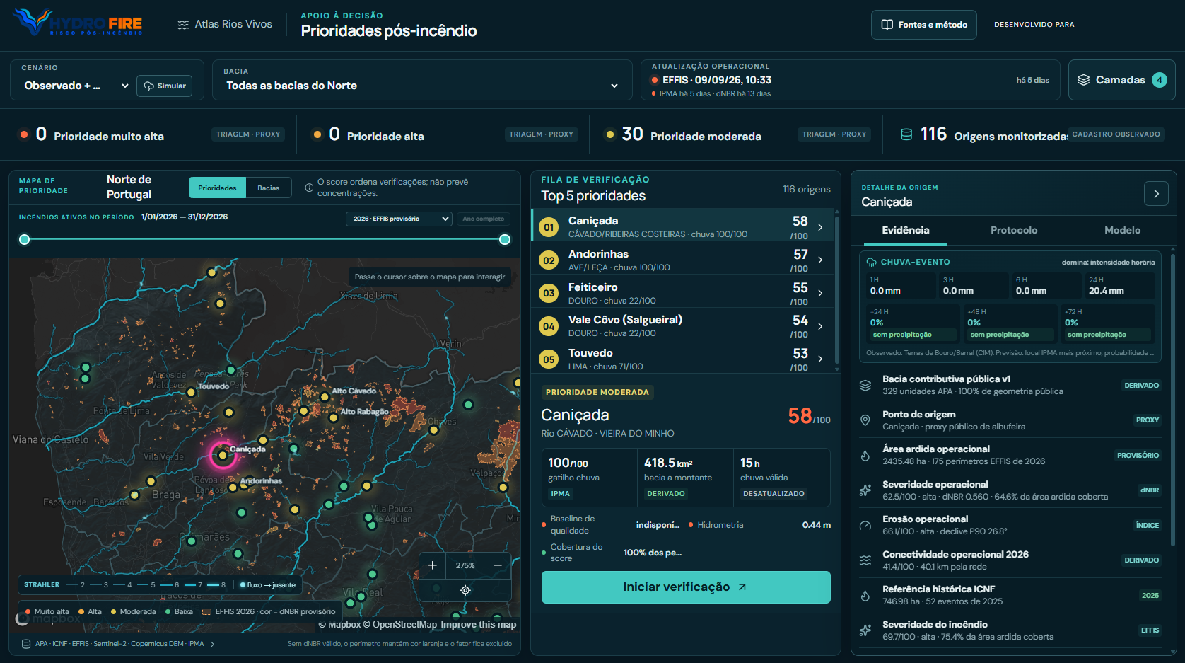
HydroFire view: priority map of northern Portugal, verification queue and evidence for each water source
An integrated view of the landscape

Demo interface in Portuguese.

BURNED AREARAINFALLWATER INTAKE

Operational overview

Understand the connection.
Guide the response.

Identify the water sources that need attention, explore priority factors and organise verification in the context of each catchment.

↓

From overview to detail

Every priority
has an explanation.

Explore the dimensions HydroFire brings together to support post-fire analysis.

Landscape and water

Water abstraction starts
before the intake.

Understand the catchment upstream of each water source and the connections between watercourses, reservoirs and monitoring stations. The hydrographic atlas puts the analysis in context.

  • River network and contributing catchments
  • Connectivity between burned areas and water sources
  • Available monitoring stations and public readings
APA · SNIAmb · InfoÁguaView sources and method

Confidence before decisions

A clear priority.
A traceable source.

Know what was observed, what was calculated and what still needs validation.

01

Integrate

Bring together mapping, wildfire data, Earth observation and rainfall within a shared geographical framework.

02

Contextualise

Combine exposure, rainfall, connectivity, fire severity and erosion. Make data coverage and freshness visible.

03

Prioritise

Set the order of verification and show the factors behind each result, with details for each water source.

Who it is for

A shared landscape.
Decisions in context.

A shared foundation for those who monitor water, manage land and interpret evidence.

WATER MANAGEMENT

Water utilities

Context for prioritising water source monitoring and preparing verification after a wildfire.

LAND MANAGEMENT

Municipalities and intermunicipal bodies

An integrated view of burned areas and their connection to the river network.

ANALYSIS AND VALIDATION

Technical teams

Sources, coverage and priority factors for analysing results and supporting decisions.

Discover HydroFire

From fire to water.
Clearer decisions.

Let’s explore your landscape, your water sources and the questions you need to answer.

Book a demo Talk to the Beyond the Hype team.
HydroFire · Post-fire priorities
HydroFire platform screenshot with map, priorities and water source details

Illustrative screenshot of the platform in Portuguese. The values shown reflect the date of capture.